
One of the most helpless feelings is to be involved in a critical security incident with no means of communication. I know the feeling firsthand. I’ve experienced not being able to communicate from dangerous and remote international locations. I’ve also been on the other end. I’ve been charged with advising someone who’s experiencing a life-threatening security incident, yet who has no way of determining his or her exact location. In such situations response, assistance, or extraction efforts are extremely challenging.
I’ve also experienced the best of these situations. In one case an individual’s location was overrun by rebels. He made his way to a safe location, but it was clear that it would not be safe for long. Fortunately, he had a satellite phone. He was able to send his exact latitude and longitude coordinates. Through an amazing set of circumstances and logistics, within twelve hours a French military helicopter showed up at his exact position and was able to get him to a secure location. I wish they could all end that way.
These two scenarios demonstrate the importance of having a third (tertiary) means of communication. For many people a mobile phone is their primary means, email (via the Internet) is their secondary, and that’s as far as it goes. The problem is that in a natural disaster or in times of economic or political crisis these are often the first things that go down, or to be intentionally shut down.
For years I carried an Iridium satellite phone. My current model is the Iridium 9575. It’s rugged and reliable. Like other devices that access the Iridium network of over sixty Low-Earth-Orbit Satellites, one can use it anywhere in the world as long as there is line-of-sight to the sky. There’s no need for cellular/mobile service or the Internet. Whether you’re in the middle of the Indian Ocean, the top of Mount Everest, or stuck in war-torn Afghanistan, with a charged battery and an Iridium subscription calling out or receiving calls is almost never an issue.
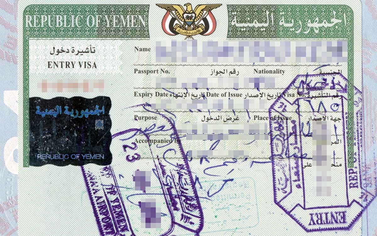
The main reason I seldom carry my satellite phone these days is that it got me into some trouble in Yemen. Arriving at Sana’a International Airport I walked past the bag screeners who seemed busy with other things. One of the more senior guards off to the side smiled and politely pointed to the x-ray machine. I smiled back and dutifully placed by backpack onto the belt. One of the screeners tilted his head sideways as he looked at the monitor and said with a heavy accent, “What’s that, it’s big.” When the bag came out he unzipped it, reached in, and pulled out my satellite phone. He looked at the 9575 like it was something I was going to use to call in drone-strikes. I ended up going through secondary screening with a room full of polite, professional agents. They eventually explained that I would have to leave the phone with them and retrieve it when I left the country. They meticulously filled out a receipt listing every serial/model number printed on the unit. Some were 12-16 characters long. They checked and rechecked the numbers, and then handed me a copy of the receipt. To my surprise, when I finally left Yemen they had my 9575 waiting for me. It had been password-protected and thus had never been accessed.
I had used various models of the DeLorme InReach since 2012. The company was bought-out by Garmin in 2016, and I’ve had a few models since. I often carried them as backup to the satellite phone. After the Yemen experience I started carrying my InReach Explorer, and left the 9575 at home. Although still a bit large, I’ve never been asked about an InReach unit when entering a county. In fact, no screener has ever given it a second look as far as I can recall. In mid-2018 Garmin released the InReach Mini. I got one as soon as I could, and never looked back.
The InReach Mini is about half the size and weight of the InReach Explorer. Whereas the Explorer is a stand-alone unit, the Mini is stand-alone for many of the most important communication and security features. These include:
• Triggering an interactive SOS message
• Easily sending preset messages to SMS and email
• Sending custom messages to SMS and email with a difficult-to-use, tiny, virtual keyboard
• Sending your exact latitude/longitude location with just a few clicks
• Setting up tracking with pinged locations every ten minutes or so
• Sending and receiving messages with others operating an InReach unit
When paired with a compatible smartphone and the free Garmin Earthmate app, most of the advanced features offered by the Explorer are available using the Mini. This includes downloading and accessing topographical maps, and using your smartphone keyboard and contacts to make writing and sending SMS or email messages very easy. Note that the larger Explorer can also be paired with a compatible smartphone and the Garmin app to access your contacts and keyboard.
There are a few things to be aware of. Like satellite phones, InReach units require a subscription. The good news is that whereas 500 global minutes would cost me about $800 a year on my satellite phone, the least-costly subscription plan for the InReach costs less than $15.00 per month. It’s also the case that using an InReach is not as intuitive as, say, a mobile phone. With a little practice, however, it’s not too difficult to operate. Finally, I would not suggest using an InReach to replace a dedicated GPS if you use one on a regular basis. The main reason to use an InReach is for communication from remote areas or during an emergency when other means of communication are not available. In such cases it may literally save your life.
As is true for other high-tech items, features and costs change every so often. For this reason I won’t take the time to list all sorts of information here that will be outdated in a few months. I will, however, demonstrate how I use the InReach when I travel.
If you’ve taken our online Soft Skills and Tactics (SST) course, you know all about Base-Monitored Movements [SST: 02.03.02]. This protocol can be used for simple travel a few hours away, or for complex evacuation movements or extraction operations. One thing they all have in common is setting waypoints, having a check-in schedule, and having a pre-determined plan of action in case one or more check-in times are missed.
For lower-risk travel my wife serves as my Base. In such circumstances, and when I have access to the Internet or mobile service, I simply text my wife at each waypoint. In this way she knows my last-known-location (LKL). This is essential in the event that I go missing and a search operation is initiated. When there’s no Internet or mobile service available, or in more high-risk situations, I use my InReach to accomplish the same task. Here’s how it works:
From an open area, or even from inside a car, I look for line-of-sight to the sky. I start up my InReach Mini and choose the “Send Preset” option. I then choose from one of my preset messages and click “Send.” The preset message is then sent to the recipients I set up earlier on my account at Garmin InReach website. Depending on the preset message chosen, my wife and any number of other individuals will receive an email and/or SMS message. This will include the preset text and a URL hyperlink to a map. When the link in the message is clicked, a browser will open and a Garmin map will be displayed showing my location. The image below is an example. This is from an actual message I sent to my wife from Egypt.
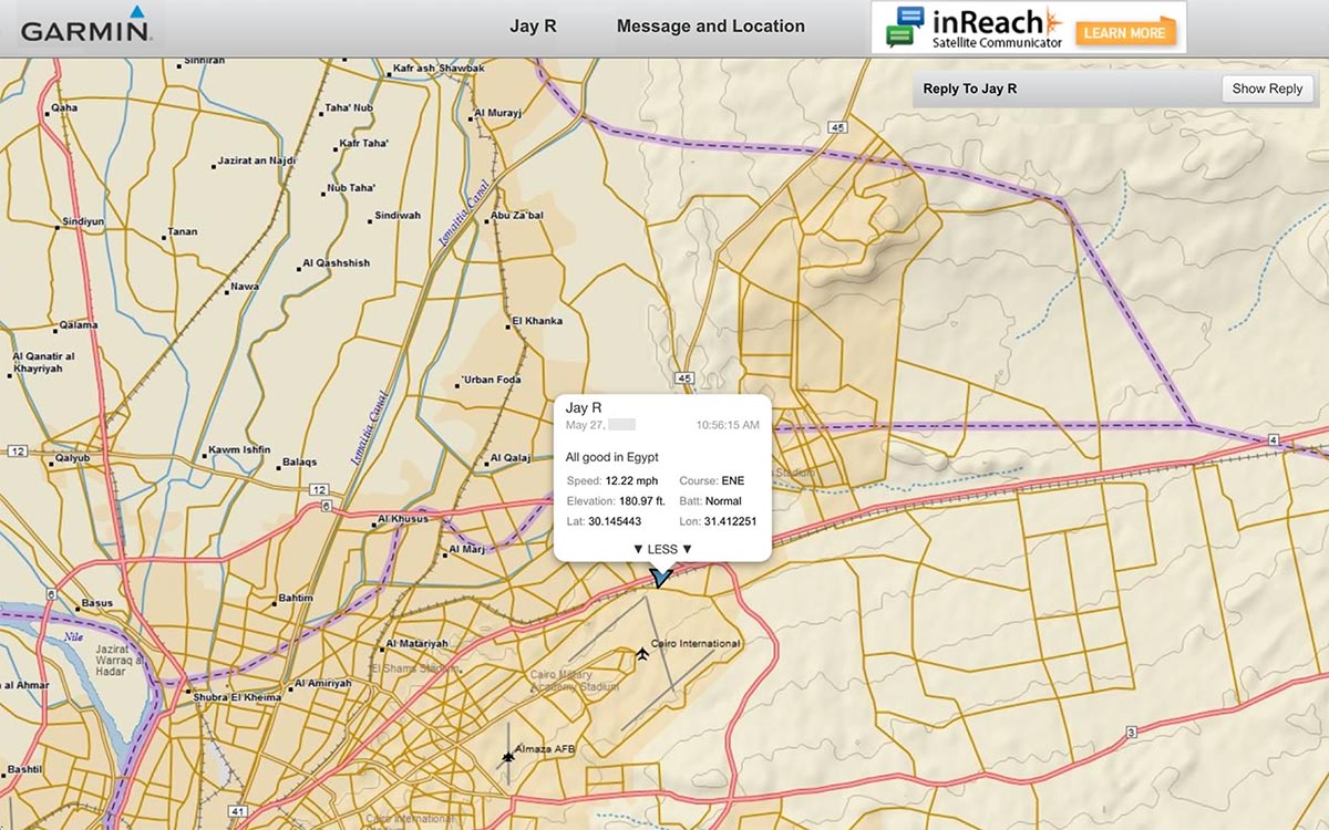
The information box is expanded in the image below for clarity.
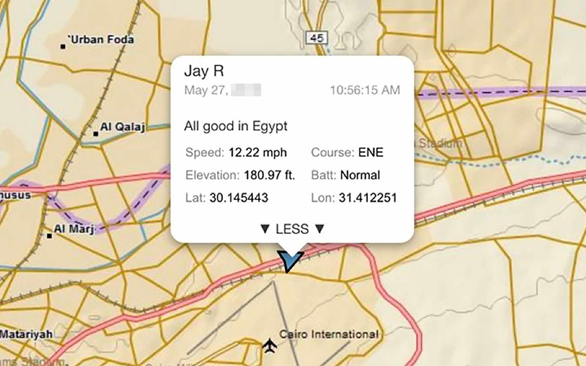
You can see the information it contains and how helpful this would be to those involved in a search operation. This simple message that took just a moment to send gives them an excellent starting point. They know my exact location at a given time, how fast I was traveling, and in what direction.
With a more expensive subscription level one can set the InReach unit to ping his or her location on a map that updates at intervals such as every ten minutes. I’ve used this when traveling in some very challenging places and had a Base monitoring my movements in near-real-time. It really is amazing what the InReach can do.
Up to three messages can be preset online along with a list of recipients to receive them. The three I use are:
• All is well. Click on link in email for my location.
• Delayed, but everything is ok.
• Pick me up here.
You can also program the Emergency Contacts that will be notified if you press the dedicated, protected SOS button.
The bottom line is that short of a satellite phone, few things can replace an InReach unit to access the Iridium satellite network. I highly recommend an InReach unit for anyone. It’s one of the most important items that I carry in my Loadout 02 bag (LL-02). Be advised, however, there are several countries in which the use of a satellite phone is illegal. These include China, India, Morocco, and Myanmar. There may be others. It’s unclear if these countries also have issues with one entering with or using a Garmin InReach unit. It’s your responsibility to check before entering any country with satellite technology.
As always, remember that Panoplia.org has no affiliate relationships with manufacturers or retail suppliers, nor do we participate in third-party advertising. We simply share our views about gear and supplies that work well for us under hard use.
2 Comments
Trackbacks/Pingbacks